Random thoughts from a book-loving Puerto Rican astronomical data scientist in Baltimore.
Showing posts with label Pictures. Show all posts
Sunday, November 22, 2015
Moving to New York City
This past October I moved to New York City to start my new job. It has been a bit of a hectic experience, but now I'm finally settling down so it's time to update my blog. I'm working at the American Museum of Natural History, specifically with the BDNYC group helping with a variety of tasks related to their science (brown dwarfs) and their students (of which there are quite a few).
In this post I'll describe my move and some of what I've been up to.
Wednesday, February 11, 2015
A Journey to Southern Patagonia and Tierra de Fuego
I've recently returned from a brief trip to the southernmost parts of Chile. Like my prior journey to Patagonia (see here), I saw many great sights and enjoyed traveling to such remote places. This particular journey featured lots of penguins and the famous Torres del Paine. For more details, and for those that may be interested in doing their own trips, keep reading.
Tuesday, September 23, 2014
A Journey to Northern Patagonia
| The Marble Caves / Las Cuevas de Marmol |
A week ago, I took a brief journey with my good friend Jackie to part of Northern Patagonia in Chile. I realize I haven't always written summaries of my trips and that's a shame. I'll have to remember to do this more often as it's fun to have it written down.
This trip consisted of a drive across various small towns as well as experiencing how the people there celebrate the Fiestas Patrias (the Chilean independence holidays), a boat trip to the fabled Marble Caves, and lots of traveling across beautiful rivers, valleys, and mountains with waterfall after waterfall. It was a great journey and my first time in these parts of Chile. In this blog post, I'll briefly recount the adventures we had, both to keep it as a memory and to perhaps help future travelers thinking of visiting Southern Chile.
As always, the pictures can be clicked to see larger versions.
Friday, March 28, 2014
Astronomy: Observing at CTIO
This past week I went to two observatories for some observing runs: Cerro Tololo International Observatory (CTIO) and La Silla Observatory. I've talked about La Silla before (here and here). However, it's been several years since I've been to CTIO. I'll briefly go over my experience there observing the Dark Energy Camera (DECam).
Saturday, September 21, 2013
Astronomy: Observing at VLT
A few weeks past, I went up to Cerro Paranal to observe with the Very Large Telescope (VLT). I was there with my officemate, Jackie Faherty, who was the PI of the program. Given that this was our first experience with the instrument (FORS2), I tagged along to learn about it and to help in any way that I could.
This blog recounts our brief adventure there.
Monday, July 29, 2013
Astronomy: Protostars and Planets VI
Two weeks ago, I attended Protostars and Planets VI, an astronomy conference held in Heidelberg, Germany. It was a large meeting and also my first time in Germany. Hence, I decided to stay a few extra days and thus this post is somewhat delayed.
In this post, I give my personal impression and experience during the conference. I'll point you here if you want a summary of the talks, particularly the earlier ones during the meeting.
Wednesday, July 3, 2013
Astronomy: Las Campanas, Round Two
![]() |
| Las Campanas Observatory |
This past weekend, I took another short trip to Las Campanas Observatory for a brief observing run. Given that my experience this time was different, and that perhaps some readers may want to learn more about the life of an astronomer, I've written this short post on my recent time there.
At least one paragraph is very science-y, so feel free to skip that one if you're not an astronomer ;)
More after the jump.
Monday, May 6, 2013
Smog in Santiago
| Santiago, Chile: April 30, 2013 |
Santiago has some of the worst air pollution of any city I've been to. Last week, I took a few pictures from my office that very vividly illustrate the problem here. The first is above, for the next few and some discussion, keep reading.
Saturday, April 6, 2013
Astronomy: Observing at Las Campanas
| Las Campanas Observatory |
A few weeks ago, I went up to Las Campanas Observatory to observe with the du Pont 2.5-meter telescope. I had only a single night, but this blog post recounts my experience there.
Monday, February 18, 2013
Astronomy: Observing at La Silla
| La Silla Observatory |
Astronomers, particularly those that deal with observations (like me), tend to go to remote places to observe the stars. These tend to be high up on mountain tops in isolated areas far from cities. This past week was the first time I visited La Silla Observatory. This post summarizes my experience from the last few days.
Monday, November 26, 2012
Chile: Summer and Winter
I've now spent over a year in Chile and have taken pictures from time to time. Here I present two pairs of pictures of approximately the same location, but shifted in time by several months. That is, one picture is taken around Summer, while the other was taken around Winter (or close enough). This showcases how the seasons change here in Santiago and it's a good opportunity to talk about how the seasons work on Earth.
As always, remember that you can click the pictures to see them larger.
More details, and the second picture, after the jump.
Sunday, August 26, 2012
Of Hurricanes, gods, and planet Jupiter
It's hurricane season in the Atlantic right now, so that means lots of news channels will be reporting on the latest storms to develop. Given that I grew up in Puerto Rico and lived a few years in Florida, I have had my share of storms and can attest to their intensity.
Above is an awesome graph created by John Nelson, a data visualization expert. The graph depicts every tropical storm and hurricane that has been recorded since 1851, color coded by intensity. The projection is polar, so we see Antarctica in the center and the US off in the edge near the right. The Southern Hemisphere hasn't been tracked until more recently, hence the fewer storms there.
This post, as you may be able to tell from the title, ties together hurricanes, storm gods, and the planet Jupiter. More information after the jump.
Tuesday, August 14, 2012
A Line of Fire Across The Andes
Today was a cold, overcast day with some light rain in Santiago. It wasn't the rainest or the coldest day I've seen, but when I looked out in the late afternoon I was impressed.
This is what I saw:
I think my camera has failed to capture the amazing scene I was seeing, but I tried my best.
This is what I saw:
I think my camera has failed to capture the amazing scene I was seeing, but I tried my best.
Thursday, June 21, 2012
Morning Mountains
Getting ready to head out for the Cool Stars 17 conference.
Today looks like a beautiful day in Chile, thanks to the bit of rain and wind yesterday. Here's what the Andes looked like this morning:
Looks like Winter has finally come...
Today looks like a beautiful day in Chile, thanks to the bit of rain and wind yesterday. Here's what the Andes looked like this morning:
Looks like Winter has finally come...
Sunday, June 17, 2012
Easter Island: Tourism! (3/3)
This is the last of my three posts on Easter Island. Part 1 described the astronomy outreach we did there, part 2 was about the transit of Venus, our main event. This part now describes all the touristy things we squeezed in when we weren't working.
First, a map:
There are, as you can imagine, tons of moai on the island. These are statues built by the natives of their ancestors many, many years ago and are the most impressive things you will see. Most were torn down and have subsequently been restored, but a few impressive ones are broken.
(Remember: you can click on the pictures to see them larger.)
All of these moai were constructed at one place: Rano Raraku, the remains of a volcano that now hosts a lake. The rocks on one side of the volcano was carved up into these great statues, which were then transported all across the island. We had with us a friend and guide, Edmundo Edwards, who told us these great stories and taught us a ton about the history of the island.
Ahu Tongariki, picture below, is one of the better known moai sites. This one has 15 huge moai.
Most moai face inland, though a few, like Ahu Akivi picture below do not. It's not clear to me why this is, but it's an interesting curiosity. Somewhat unusual is that the stones around Ahu Akivi are all river stones, but there are no rivers on the island (they were recently imported from the mainland).
The highest point of the island, Maunga Terevaka, stands at 507 meters and is the tallest mountain in a 4000 km radius. That shouldn't be too surprising considering there is practically no land (just a few small islands) in that area. Easter Island is truly isolated. We climbed this hill at sunset as we were buffeted by the winds. It was a gruesome hike (I may be exaggerating here), but we made it.
There are two beaches on the island (the rest of the shore is rocky or cliffs). One was supposed to have pink sand, but it wasn't that pink. I've seen better beaches, but this one was still cool. And it had moai!
On our last day of tourism we visited the ruins of Orongo. This ceremonial village is located near the south at the edge of Rano Kau, which is picture below.
Orongo is important as it was used for the Birdman Cult on the island which replaced the moai-building period. The birdman cult is present in other islands and is tied to the creator god Make-Make.
There was a ceremony every year in which a champion would go out to swim to the island to gather the first egg laid by the manutara, the sooty tern (a bird). The host of the winner would then become famous as the tangata-manu (the birdman) and would be considered sacred.
And finally, here's a shot of Ahu Tahai at sunset on June 5, 2012 (the day of the transit of Venus).
First, a map:
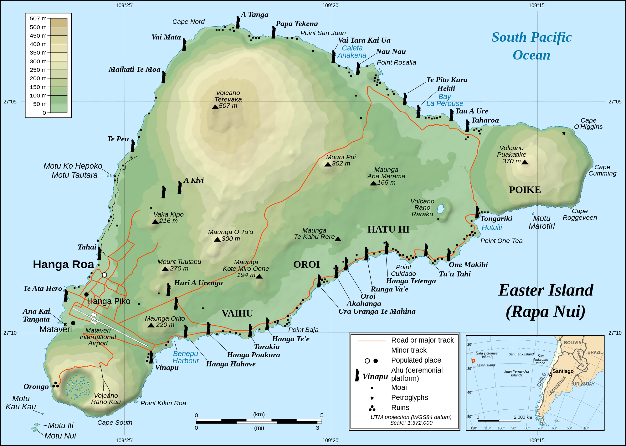
| Easter Island. The map I used in my activity has a few embarrassing errors (this one is fine). |
There are, as you can imagine, tons of moai on the island. These are statues built by the natives of their ancestors many, many years ago and are the most impressive things you will see. Most were torn down and have subsequently been restored, but a few impressive ones are broken.
(Remember: you can click on the pictures to see them larger.)
![]() |
| Broken moai at Ahu Akahanga |
All of these moai were constructed at one place: Rano Raraku, the remains of a volcano that now hosts a lake. The rocks on one side of the volcano was carved up into these great statues, which were then transported all across the island. We had with us a friend and guide, Edmundo Edwards, who told us these great stories and taught us a ton about the history of the island.
| Moai at Rano Raraku. |
![]() |
| The lake atop Rano Raraku. |
Ahu Tongariki, picture below, is one of the better known moai sites. This one has 15 huge moai.
![]() |
| Ahu Tongariki |
Most moai face inland, though a few, like Ahu Akivi picture below do not. It's not clear to me why this is, but it's an interesting curiosity. Somewhat unusual is that the stones around Ahu Akivi are all river stones, but there are no rivers on the island (they were recently imported from the mainland).
| Ahu Akivi |
The highest point of the island, Maunga Terevaka, stands at 507 meters and is the tallest mountain in a 4000 km radius. That shouldn't be too surprising considering there is practically no land (just a few small islands) in that area. Easter Island is truly isolated. We climbed this hill at sunset as we were buffeted by the winds. It was a gruesome hike (I may be exaggerating here), but we made it.
| Almost at the summit of Maunga Terevaka. |
There are two beaches on the island (the rest of the shore is rocky or cliffs). One was supposed to have pink sand, but it wasn't that pink. I've seen better beaches, but this one was still cool. And it had moai!
| Moai at Anakena beach |
On our last day of tourism we visited the ruins of Orongo. This ceremonial village is located near the south at the edge of Rano Kau, which is picture below.
![]() |
| Rano Kau. The crater is about a mile in diameter. |
Orongo is important as it was used for the Birdman Cult on the island which replaced the moai-building period. The birdman cult is present in other islands and is tied to the creator god Make-Make.
| Orongo ceremonial village, |
There was a ceremony every year in which a champion would go out to swim to the island to gather the first egg laid by the manutara, the sooty tern (a bird). The host of the winner would then become famous as the tangata-manu (the birdman) and would be considered sacred.
| Motu Nui, where the manutara would have their nests is the 'large' island more distant in this shot. |
And finally, here's a shot of Ahu Tahai at sunset on June 5, 2012 (the day of the transit of Venus).
Tuesday, June 12, 2012
Easter Island: Transit of Venus (2/3)
This is the second of a three part post series on our recent trip to Easter Island. Previously I wrote about the outreach activities we did on the days leading up to the transit. In this post I describe the main event itself: the transit of Venus.
I've previously talked about the transit of Venus (here) and described the math involved in determining the distance (here). Hence, I'll skip the overview and jump right into the details.
Sunday, June 10, 2012
Easter Island: Outreach Activities (1/3)
This past week I've been with a group of astronomers on Easter Island to do outreach, observe the transit of Venus, and do some tourism. This is the first of a 3 post series describing our adventures. Part 1 is a description of the outreach activities we did at Easter Island. Part 2 describes our viewing of the transit of Venus along with our distance estimate, and Part 3 is about the places we visited.
Saturday, April 28, 2012
Chile After the Rain
Yesterday we had a lot of rain in Santiago. The day started foggy and cold:
It then started raining, with thunder and lightning, and eventually even hail.
Getting that much rain in Santiago all at once is rare, but it was necessary given that the Metropolitan Region has been in drought for the past few years. The amount of rain thus far this year (7.3 mm, including a brief rain shower in early April) still is less than the yearly average up to this date of 11.5 mm.
The news today is reporting that last night we saw flooding in some sectors with a few minor landslides. The main problem is traffic jams or "tacos" that were an hour longer than usual. The metro was very crowded and apparently also suffered from some technical problems near Manquehue that caused delays, but it's not clear if it was due to the rainy weather.
Today, however, the day is expected to be clear or partly cloudy.
I woke up this morning to see a beautiful sunrise over mountains that are now capped with snow:
Winter is truly coming...
It then started raining, with thunder and lightning, and eventually even hail.
Getting that much rain in Santiago all at once is rare, but it was necessary given that the Metropolitan Region has been in drought for the past few years. The amount of rain thus far this year (7.3 mm, including a brief rain shower in early April) still is less than the yearly average up to this date of 11.5 mm.
The news today is reporting that last night we saw flooding in some sectors with a few minor landslides. The main problem is traffic jams or "tacos" that were an hour longer than usual. The metro was very crowded and apparently also suffered from some technical problems near Manquehue that caused delays, but it's not clear if it was due to the rainy weather.
![]() |
| The lack of proper drainage in Santiago causes flooding very quickly. Credit: instagr.am/ maritesanz |
Today, however, the day is expected to be clear or partly cloudy.
I woke up this morning to see a beautiful sunrise over mountains that are now capped with snow:
Winter is truly coming...
Monday, April 9, 2012
Astronomy: MOSFIRE First Light
MOSFIRE, or the Multi-Object Spectrometer For Infra-Red Exploration, has seen first light at W.M. Keck Observatory. This is means the instrument was mounted on the 10-meter diameter Keck I telescope and took its first images of the night sky. It's a big step as it shows that things are moving along.
The MOSFIRE instrument had been under construction at UCLA during my time there and several of my friends worked on it. It is good to see their efforts paid off and the instrument is online and will soon be taking data.
Monday, April 2, 2012
Iguazu Falls Trip: Brazil (3/3)
Subscribe to:
Comments (Atom)


